|
|
Antenna Structure Registration 1059971 |
 |
Registration Info | Registration Number: 1059971 |
| File Number: A1091302 |
| FAA Study: 98-ACE-0440-OE |
| FAA Issue Date: 05/14/1998 |
| Status: Constructed |
| Date Constructed: 07/01/1997 |
| FAA EMI: N |
| NEPA: N |
Structure Info
| Structure Type: BTWR |
| Structure Coordinates: 38-50-30.0 N 97-36-35.0 W (NAD 83) |
| Structure Coordinates: 38-50-30.0 N 97-36-33.9 W (Converted to NAD 27) |
| Structure Address: 131 N Santa Fe |
| Structure City: Salina, KS |
| Structure County: Saline County |
| Painting & Lighting Info |
FAA Chapters: NONE |
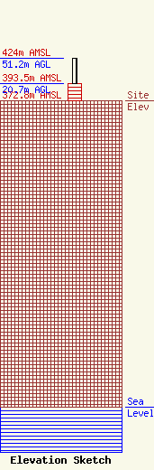
| Elevation Info |
Site Elevation: 372.8 meters (1223 ft) |
| Height of Structure: 20.7 meters (68 feet) |
| Overall Height Above Ground: 51.2 meters (168 feet) |
| Overall Height Above Mean Sea Level: 424 meters (1391 feet) |
| Owner Info | Rocking M Media, LLC
604 North Main
Wichita, KS 67203
(970) 309-0643
cmiller@rockingmradio.com |
| Contact Info | Rocking M Media, LLC
604 North Main
Wichita, KS 67203
Christopher Miller
(970) 309-0643
cmiller@rockingmradio.com |
