|
|
Antenna Structure Registration 1060215 |
 |
Registration Info | Registration Number: 1060215 |
| File Number: A0070638 |
| FAA Study: 85-AGL-1271-OE |
| FAA Issue Date: 10/07/1985 |
| Status: Terminated |
| Date Constructed: 11/01/1985 |
| NEPA: N |
Structure Info
| Structure Type: TOWER |
| Structure Coordinates: 39-55-42.0 N 81-59-6.0 W (NAD 83) |
| Structure Coordinates: 39-55-41.8 N 81-59-06.5 W (Converted to NAD 27) |
| Structure Address: 629 Downard Rd |
| Structure City: Zanesville, OH |
| Structure County: Muskingum County |
| Painting & Lighting Info |
FCC Paragraph(s): 1, 3, 4, 13, 21 |
Remarks: RED LIGHTS/PAINT |
| Elevation Info |
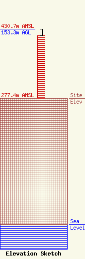
Site Elevation: 277.4 meters (910 ft) |
| Height of Structure: 138.7 meters (455 feet) |
| Overall Height Above Ground: 153.3 meters (503 feet) |
| Overall Height Above Mean Sea Level: 430.7 meters (1413 feet) |
| Owner Info | SOUTHEASTERN OHIO TELEVISION SYSTEM DBA = WHIZ TV
629 DOWNARD RD
ZANESVILLE, OH 43701
(740) 453-0361
WWW.WHIZAMFMTV.COM |
