|
|
Antenna Structure Registration 1060256 |
 |
Registration Info | Registration Number: 1060256 |
| File Number: A1306404 |
| FAA Study: 98-AGL-5767-OE |
| FAA Issue Date: 01/07/1999 |
| Status: Dismantled |
| Date Constructed: 05/01/1999 |
| FAA EMI: N |
| NEPA: N |
Structure Info
|
| Structure Coordinates: 44-44-58.0 N 85-35-39.0 W (NAD 83) |
| Structure Coordinates: 44-44-58.0 N 85-35-38.7 W (Converted to NAD 27) |
| Structure Address: North Of Carver St., Between Hastings St. & Garfield Ave. |
| Structure City: Traverse City, MI |
| Structure County: Grand Traverse County |
| Painting & Lighting Info |
FAA Chapters: NONE |
Remarks: Removed expiration date from determination. Scenario 1./jjs/case#635066 |
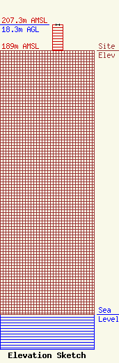
| Elevation Info |
Site Elevation: 189 meters (620 ft) |
| Height of Structure: 18.3 meters (60 feet) |
| Overall Height Above Ground: 18.3 meters (60 feet) |
| Overall Height Above Mean Sea Level: 207.3 meters (680 feet) |
| Owner Info | NORTHERN MICHIGAN RADIO, INC.
1020 Hastings
TRAVERSE CITY, MI 49686
(231) 947-0003
|
| Info |
