|
|
Antenna Structure Registration 1060743 |
 |
Registration Info | Registration Number: 1060743 |
| File Number: A1206627 |
| FAA Study: 87-AEA-0945-OE |
| FAA Issue Date: 11/26/1986 |
| Status: Constructed |
| Date Constructed: 01/01/1966 |
| FAA EMI: N |
| NEPA: N |
Structure Info
| Structure Type: 3TA3 |
| Structure Coordinates: 42-9-14.0 N 76-50-46.0 W (NAD 83) |
| Structure Coordinates: 42-09-13.7 N 76-50-47.2 W (Converted to NAD 27) |
| Structure Address: Twr 3 - Philo Road Extension |
| Structure City: Horseheads, NY |
| Structure County: Chemung County |
| Painting & Lighting Info |
FCC Paragraph(s): 1, 3, 11, 21 |
Remarks: RED LIGHTS/PAINT |
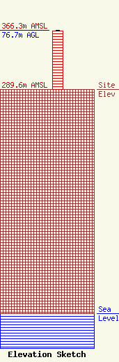
| Elevation Info |
Site Elevation: 289.6 meters (950 ft) |
| Height of Structure: 75.7 meters (248 feet) |
| Overall Height Above Ground: 76.7 meters (252 feet) |
| Overall Height Above Mean Sea Level: 366.3 meters (1202 feet) |
| Owner Info | Montrose Broadcasting Corporation
251 High Street
Montrose, PA 18801
(270) 278-2811
james.baker@wpel.org |
| Contact Info | Montrose Broadcasting Corporation
251 High Street
Montrose, PA 18801
James Baker
(270) 278-2811
james.baker@wpel.org |
