|
|
Antenna Structure Registration 1060937 |
 |
Registration Info | Registration Number: 1060937 |
| File Number: A1276571 |
| FAA Study: 69-BOS-183-OE |
| FAA Issue Date: 06/27/1969 |
| Status: Constructed |
| Date Constructed: 01/01/1969 |
| FAA EMI: N |
| NEPA: N |
Structure Info
| Structure Type: TOWER |
| Structure Coordinates: 42-12-0.0 N 76-51-29.0 W (NAD 83) |
| Structure Coordinates: 42-11-59.7 N 76-51-30.2 W (Converted to NAD 27) |
| Structure Address: Prospect Hill |
| Structure City: Horseheads, NY |
| Structure County: Chemung County |
| Painting & Lighting Info |
FCC Paragraph(s): 1, 3, 11, 21 |
Remarks: RED LIGHTS/PAINT |
| Elevation Info |
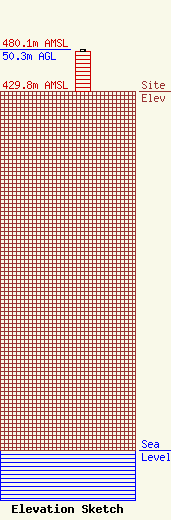
Site Elevation: 429.8 meters (1410 ft) |
| Height of Structure: 49 meters (161 feet) |
| Overall Height Above Ground: 50.3 meters (165 feet) |
| Overall Height Above Mean Sea Level: 480.1 meters (1575 feet) |
| Owner Info | Seven Mountains Media, LLC
115 West Main Street
Frankfort, KY 40601
(502) 875-1130
towers@7mountainsmedia.com |
| Contact Info | Seven Mountains Media, LLC
135 White Bridge Rd
Middletown, NY 10940
Bud Williamson
(914) 213-1710
bud@7mountainsmedia.com |
