|
|
Antenna Structure Registration 1061162 |
 |
Registration Info | Registration Number: 1061162 |
| File Number: A1004489 |
| FAA Study: 2016-ASO-4456-OE |
| FAA Issue Date: 03/29/2016 |
| Status: Constructed |
| Date Constructed: 01/01/1995 |
Structure Info
| Structure Type: LTOWER |
| Structure Coordinates: 28-21-23.0 N 80-44-45.8 W (NAD 83) |
| Structure Coordinates: 28-21-22.0 N 80-44-46.6 W (Converted to NAD 27) |
| Structure Address: 200 South Burnett Road |
| Structure City: Cocoa, FL |
| Structure County: Brevard County |
| Painting & Lighting Info |
FAA Chapters: NONE |
Remarks: PRIOR STUDY 1998-ASO-7474-OE |
| Elevation Info |
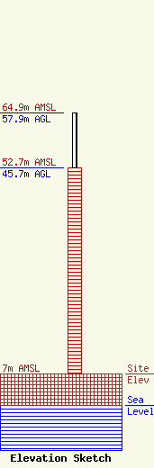
Site Elevation: 7 meters (23 ft) |
| Height of Structure: 45.7 meters (150 feet) |
| Overall Height Above Ground: 57.9 meters (190 feet) |
| Overall Height Above Mean Sea Level: 64.9 meters (213 feet) |
| Owner Info | NATIONAL CHRISTIAN NETWORK, INC.
1150 W KING ST
COCOA, FL 32922
(321) 632-1000
rkassis@ncnradio.com |
| Contact Info | NATIONAL CHRISTIAN NETWORK, INC.
1150 W KING ST
COCOA, FL 32922
Raymond Kassis
(321) 632-1000
rkassis@ncnradio.com |
