|
|
Antenna Structure Registration 1062660 |
 |
Registration Info | Registration Number: 1062660 |
| File Number: A0098413 |
| Status: Constructed |
| Date Constructed: 01/01/1956 |
| FAA EMI: N |
| NEPA: N |
Structure Info
| Structure Type: TOWER |
| Structure Coordinates: 33-35-19.0 N 86-19-14.0 W (NAD 83) |
| Structure Coordinates: 33-35-18.6 N 86-19-14.1 W (Converted to NAD 27) |
| Structure Address: On Highway 78 -approx. 1 Mile South Of Exit 156 (i-20) |
| Structure City: Pell City, AL |
| Structure County: St. Clair County |
| Painting & Lighting Info |
FCC Paragraph(s): 1, 3, 11, 21 |
| Elevation Info |
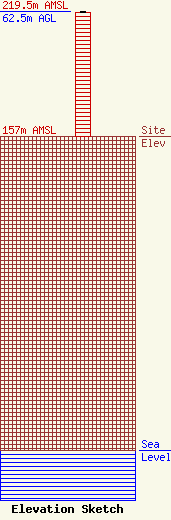
Site Elevation: 157 meters (515 ft) |
| Height of Structure: 61.9 meters (203 feet) |
| Overall Height Above Ground: 62.5 meters (205 feet) |
| Overall Height Above Mean Sea Level: 219.5 meters (720 feet) |
| Owner Info | Williamson Broadcasting, Inc.
22 Cogswell Avenue
Pell City, AL 35125
(205) 338-1430
mccainp@nti.net |
| Contact Info | Williamson Broadcasting, Inc
22 Cogswell Avenue
Pell City, AL 35125
Doug Williamson
(205) 338-1430
mccainp@nti.net |
