|
|
Antenna Structure Registration 1063187 |
 |
Registration Info | Registration Number: 1063187 |
| File Number: A0643042 |
| FAA Study: 91-ANE-085-OE |
| FAA Issue Date: 07/07/1993 |
| Status: Dismantled |
| Date Constructed: 04/18/1995 |
| FAA EMI: N |
| NEPA: N |
Structure Info
| Structure Type: TOWER |
| Structure Coordinates: 43-44-38.0 N 70-20-3.0 W (NAD 83) |
| Structure Coordinates: 43-44-37.7 N 70-20-04.8 W (Converted to NAD 27) |
| Structure Address: 115 Hardy Rd |
| Structure City: Falmouth, ME |
| Structure County: Cumberland County |
| Painting & Lighting Info |
FAA Circular #: 70/7460-1H |
FAA Chapters: 2, 3, 4, 6, 8 |
Remarks: DUAL MEDIUM INTENSITY |
| Elevation Info |
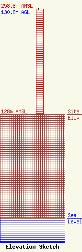
Site Elevation: 128 meters (420 ft) |
| Height of Structure: 130.8 meters (429 feet) |
| Overall Height Above Ground: 130.8 meters (429 feet) |
| Overall Height Above Mean Sea Level: 258.8 meters (849 feet) |
| Owner Info | TOWER SPECIALISTS INC
35 HARDY RD
FALMOUTH, ME 04105
(207) 797-8325
|
