|
|
Antenna Structure Registration 1063268 |
 |
Registration Info | Registration Number: 1063268 |
| File Number: A0614694 |
| FAA Study: 98-ANE-0391-OE |
| FAA Issue Date: 03/17/1999 |
| Status: Constructed |
| Date Constructed: 01/01/1959 |
| FAA EMI: N |
| NEPA: N |
Structure Info
| Structure Type: TOWER |
| Structure Coordinates: 41-31-7.0 N 73-1-0.0 W (NAD 83) |
| Structure Coordinates: 41-31-06.7 N 73-01-01.6 W (Converted to NAD 27) |
| Structure Address: Site Is Located 1,550' Nw Of Int. Clark Hill & Peach Orchard Roads |
| Structure City: Waterbury, CT |
| Structure County: New Haven County |
| Painting & Lighting Info |
FCC Paragraph(s): 1, 3, 11, 21 |
Remarks: RED LIGHTS/PAINT. |
| Elevation Info |
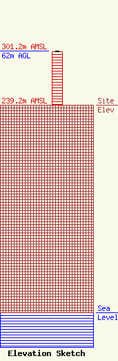
Site Elevation: 239.2 meters (785 ft) |
| Height of Structure: 61.4 meters (201 feet) |
| Overall Height Above Ground: 62 meters (203 feet) |
| Overall Height Above Mean Sea Level: 301.2 meters (988 feet) |
| Owner Info | Counterpoint Communications, Inc.
15 Peach Orchard Road
Prospect, CT 06712-1052
(203) 758-6800
cci-ct@snet.net |
| Info |
