|
|
Antenna Structure Registration 1063339 |
 |
Registration Info | Registration Number: 1063339 |
| File Number: A0073937 |
| FAA Study: 98-AGL-5970-OE |
| FAA Issue Date: 01/07/1999 |
| Status: Granted |
| NEPA: N |
Structure Info
| Structure Type: TOWER |
| Structure Coordinates: 45-1-28.0 N 84-43-44.0 W (NAD 83) |
| Structure Coordinates: 45-01-28.0 N 84-43-43.9 W (Converted to NAD 27) |
| Structure Address: 232 S Townline Rd |
| Structure City: Gaylord, MI |
| Structure County: Otsego County |
| Painting & Lighting Info |
FAA Circular #: |
FAA Chapters: NONE |
Remarks: Removed expiration date from determination. Scenario 1./jjs/case#635066 |
| Elevation Info |
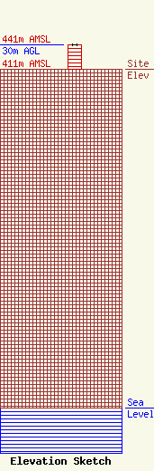
Site Elevation: 411 meters (1348 ft) |
| Height of Structure: 30 meters (98 feet) |
| Overall Height Above Ground: 30 meters (98 feet) |
| Overall Height Above Mean Sea Level: 441 meters (1447 feet) |
| Owner Info | GRACE BAPTIST CHRISTIAN SCHOOL DBA = GRACE BAPTIST CHURCH
232 S TOWNLINE RD
GAYLORD, MI 49735
(517) 732-5676
|
