|
|
Antenna Structure Registration 1064185 |
 |
Registration Info | Registration Number: 1064185 |
| File Number: A1181266 |
| FAA Study: 99-ASW-0411-OE |
| FAA Issue Date: 04/19/1999 |
| Status: Constructed |
| Date Constructed: 06/23/2003 |
| FAA EMI: N |
| NEPA: N |
Structure Info
|
| Structure Coordinates: 31-52-19.0 N 95-10-1.0 W (NAD 83) |
| Structure Coordinates: 31-52-18.4 N 95-10-00.2 W (Converted to NAD 27) |
| Structure Address: 2.9 Km Sw |
| Structure City: Gallatin, TX |
| Structure County: Cherokee County |
| Painting & Lighting Info |
FAA Circular #: 70/7460-1J |
FAA Chapters: 3, 4, 6, 13 |
Remarks: Removed expiration and final dates from determination. Scenario 2./jjs/case#635066 |
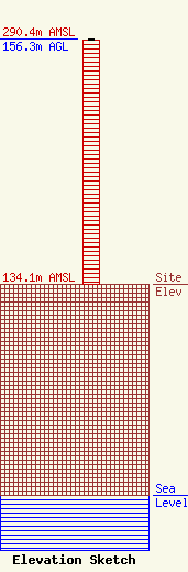
| Elevation Info |
Site Elevation: 134.1 meters (440 ft) |
| Height of Structure: 155.4 meters (510 feet) |
| Overall Height Above Ground: 156.3 meters (513 feet) |
| Overall Height Above Mean Sea Level: 290.4 meters (953 feet) |
| Owner Info | Educational Radio Foundation of East Texas, Inc.
8525
Tyler, TX 75711
(903) 508-6888
troy@kvne.com |
| Contact Info | Hardy, Carey, Chautin & Balkin, LLP
1080 West Causeway Approach
Mandeville, LA 70471
Mark Balkin
(985) 629-0777
mbalkin@hardycarey.com |
