|
|
Antenna Structure Registration 1064478 |
 |
Registration Info | Registration Number: 1064478 |
| File Number: A0909272 |
| FAA Study: 99-AGL-2646-OE |
| FAA Issue Date: 06/23/1999 |
| Status: Constructed |
| Date Constructed: 10/09/1998 |
| FAA EMI: N |
| NEPA: N |
Structure Info
| Structure Type: TOWER |
| Structure Coordinates: 43-32-32.0 N 96-43-35.0 W (NAD 83) |
| Structure Coordinates: 43-32-32.1 N 96-43-33.8 W (Converted to NAD 27) |
| Structure Address: 500 Phillips Ave |
| Structure City: Sioux Falls, SD |
| Structure County: Minnehaha County |
| Painting & Lighting Info |
FAA Chapters: NONE |
Remarks: Removed expiration date from determination. Scenario 1./jjs/case#635066 |
| Elevation Info |
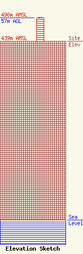
Site Elevation: 439 meters (1440 ft) |
| Height of Structure: 57 meters (187 feet) |
| Overall Height Above Ground: 57 meters (187 feet) |
| Overall Height Above Mean Sea Level: 496 meters (1627 feet) |
| Owner Info | Midwest Communications, Inc.
904 Grand Avenue
Wausau, WI 54403
(715) 842-1437
paul.rahmlow@mwcradio.com |
| Contact Info | Midwest Communications, Inc.
904 Grand Avenue
Wausau, WI 54403
Paul Rahmlow
(715) 842-1437
paul.rahmlow@mwcradio.com |
