|
|
Antenna Structure Registration 1064584 |
 |
Registration Info | Registration Number: 1064584 |
| File Number: A1309472 |
| FAA Study: 2024-ASO-19003-OE |
| FAA Issue Date: 12/10/2024 |
| Status: Constructed |
| Date Constructed: 01/01/1950 |
| NEPA: N |
Structure Info
| Structure Type: LTOWER |
| Structure Coordinates: 33-56-28.0 N 83-23-55.0 W (NAD 83) |
| Structure Coordinates: 33-56-27.6 N 83-23-55.4 W (Converted to NAD 27) |
| Structure Address: 850 Bobbin Mill Road |
| Structure City: Athens, GA |
| Structure County: Clarke County |
| Painting & Lighting Info |
FAA Circular #: 70/7460-1M |
FAA Chapters: 4, 8, 15 |
Remarks: OM&L to remain the same as prior study = A MED-DUAL SYSTEM |
Remarks: PRIOR STUDY 2022-ASO-9255-OE |
Remarks: OM&L to remain the same as prior study = A MED-DUAL SYSTEM |
Remarks: PRIOR STUDY 2022-ASO-9255-OE |
| Elevation Info |
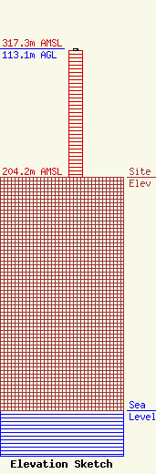
Site Elevation: 204.2 meters (670 ft) |
| Height of Structure: 111.1 meters (365 feet) |
| Overall Height Above Ground: 113.1 meters (371 feet) |
| Overall Height Above Mean Sea Level: 317.3 meters (1041 feet) |
| Owner Info | American Towers LLC
10 Presidential Way
Woburn, MA 01801
(781) 926-4500
faa-fcc@americantower.com |
| Contact Info | American Towers LLC
10 Presidential Way
Woburn, MA 01801
(781) 926-4500
faa-fcc@americantower.com |
