|
|
Antenna Structure Registration 1064637 |
 |
Registration Info | Registration Number: 1064637 |
| File Number: A1240882 |
| FAA Study: 2016-ASO-31670-OE |
| FAA Issue Date: 03/03/2017 |
| Status: Constructed |
| Date Constructed: 03/08/2017 |
| NEPA: N |
Structure Info
| Structure Type: 2GTA2 |
| Structure Coordinates: 26-45-20.0 N 80-21-59.8 W (NAD 83) |
| Structure Coordinates: 26-45-18.8 N 80-22-00.6 W (Converted to NAD 27) |
| Structure Address: North Tower - Loxahatche & Cole Roads |
| Structure City: Loxahatche, FL |
| Structure County: Palm Beach County |
| Painting & Lighting Info |
FAA Circular #: 70/7460-1L |
FAA Chapters: 3, 4, 5, 12 |
| Elevation Info |
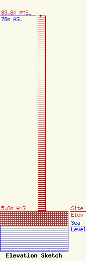
Site Elevation: 5.8 meters (19 ft) |
| Height of Structure: 78 meters (256 feet) |
| Overall Height Above Ground: 78 meters (256 feet) |
| Overall Height Above Mean Sea Level: 83.8 meters (275 feet) |
| Owner Info | WPB FCC License Sub, LLC
3415 University Avenue, West
St. Paul, MN 55114
(651) 642-4336
kshuldes@hbi.com |
| Contact Info | Wilkinson Barker Knauer, LLP
1800 M Street, N.W.
Washington, DC 20036
David O'Connor
(202) 383-3429
doconnor@wbklaw.com |
