|
|
Antenna Structure Registration 1064884 |
 |
Registration Info | Registration Number: 1064884 |
| File Number: A0778514 |
| FAA Study: 2012-AEA-2466-OE |
| FAA Issue Date: 05/15/2012 |
| Status: Constructed |
| Date Constructed: 11/23/2001 |
| FAA EMI: N |
| NEPA: N |
Structure Info
| Structure Type: TOWER |
| Structure Coordinates: 40-20-55.9 N 75-54-6.2 W (NAD 83) |
| Structure Coordinates: 40-20-55.6 N 75-54-07.5 W (Converted to NAD 27) |
| Structure Address: Skyline Drive, .1 Mi N Of Fire Tower |
| Structure City: Reading, PA |
| Structure County: Berks County |
| Painting & Lighting Info |
FAA Circular #: 70/7460-1K |
FAA Chapters: 4, 8, 12 |
Remarks: PRIOR STUDY 1995-AEA-2058-OE |
| Elevation Info |
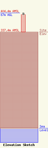
Site Elevation: 337.4 meters (1107 ft) |
| Height of Structure: 61 meters (200 feet) |
| Overall Height Above Ground: 67 meters (220 feet) |
| Overall Height Above Mean Sea Level: 404.4 meters (1327 feet) |
| Owner Info | COUNTY OF BERKS
633 COURT STREET
READING, PA 19601-3540
Brian Gottschall
(800) 237-0079
CBreneiser@countyofberks.com |
| Contact Info | L.R. Kimball
4400 Deer Path Rd. Suite 105
Harrisburg, PA 17110
(717) 221-8820
Rusty.himelwright@lrkimball.com |
