|
|
Antenna Structure Registration 1065171 |
 |
Registration Info | Registration Number: 1065171 |
| File Number: A1342714 |
| FAA Study: 2020-ANM-5486-OE |
| FAA Issue Date: 10/26/2020 |
| Status: Constructed |
| Date Constructed: 06/01/1983 |
| NEPA: N |
Structure Info
| Structure Type: GTOWER |
| Structure Coordinates: 47-6-8.1 N 119-14-28.2 W (NAD 83) |
| Structure Coordinates: 47-06-08.6 N 119-14-24.1 W (Converted to NAD 27) |
| Structure Address: 11768 Kittleson Rd Ne / Us-wa-5062 |
| Structure City: Moses Lake, WA |
| Structure County: Grant County |
| Painting & Lighting Info |
FAA Circular #: 70/7460-1L |
FAA Chapters: 4, 8, 12 |
Remarks: PRIOR STUDY 2012-ANM-3194-OE |
| Elevation Info |
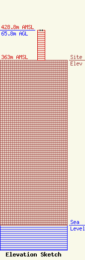
Site Elevation: 363 meters (1191 ft) |
| Height of Structure: 65.5 meters (215 feet) |
| Overall Height Above Ground: 65.8 meters (216 feet) |
| Overall Height Above Mean Sea Level: 428.8 meters (1407 feet) |
| Owner Info | VB-S1 Assets, LLC
22 W Atlantic Avenue
Delray Beach, FL 33444
(561) 406-4015
fcc-faa@verticalbridge.com |
| Contact Info | VB-S1 Assets, LLC
22 W Atlantic Avenue
Delray Beach, FL 33444
Richard Hickey
(561) 406-4015
fcc-faa@verticalbridge.com |
