|
|
Antenna Structure Registration 1065247 |
 |
Registration Info | Registration Number: 1065247 |
| File Number: A0075904 |
| FAA Study: 99-ACE-0572-OE |
| FAA Issue Date: 05/27/1999 |
| Status: Granted |
| NEPA: N |
Structure Info
| Structure Type: BTWR |
| Structure Coordinates: 37-41-15.0 N 97-20-14.0 W (NAD 83) |
| Structure Coordinates: 37-41-14.9 N 97-20-12.8 W (Converted to NAD 27) |
| Structure Address: 125 N. Market St. |
| Structure City: Wichita, KS |
| Structure County: Sedgwick County |
| Painting & Lighting Info |
FAA Circular #: 70/7460-1J |
FAA Chapters: 3, 4, 5, 13 |
| Elevation Info |
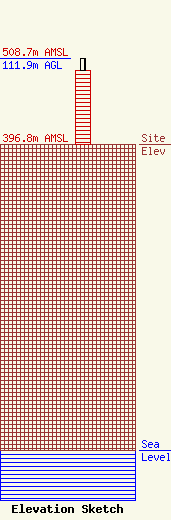
Site Elevation: 396.8 meters (1302 ft) |
| Height of Structure: 96.7 meters (317 feet) |
| Overall Height Above Ground: 111.9 meters (367 feet) |
| Overall Height Above Mean Sea Level: 508.7 meters (1669 feet) |
| Owner Info | TURNER COMMUNICATIONS, INC.
3141 BEACH VIEW COURT
LAS VEGAS, NV 89117
(702) 256-8030
|
