|
|
Antenna Structure Registration 1065445 |
 |
Registration Info | Registration Number: 1065445 |
| File Number: A0920531 |
| FAA Study: 2011-AGL-7241-OE |
| FAA Issue Date: 11/28/2011 |
| Status: Constructed |
| Date Constructed: 10/01/2000 |
| FAA EMI: N |
| NEPA: N |
Structure Info
| Structure Type: TOWER |
| Structure Coordinates: 41-1-26.2 N 85-3-50.8 W (NAD 83) |
| Structure Coordinates: 41-01-26.0 N 85-03-50.9 W (Converted to NAD 27) |
| Structure Address: Tillman Road |
| Structure City: Fort Wayne, IN |
| Structure County: Allen County |
| Painting & Lighting Info |
FAA Circular #: 70/7460-1K |
FAA Chapters: 4, 8, 12 |
Remarks: PRIOR STUDY 1999-AGL-1741-OE |
| Elevation Info |
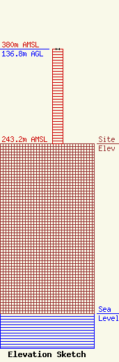
Site Elevation: 243.2 meters (798 ft) |
| Height of Structure: 136.8 meters (449 feet) |
| Overall Height Above Ground: 136.8 meters (449 feet) |
| Overall Height Above Mean Sea Level: 380 meters (1247 feet) |
| Owner Info | Global Tower, LLC. through American Towers, LLC
10 Presidential Way
Woburn, MA 01801
(678) 564-3236
faa-fcc@americantower.com |
| Contact Info | American Towers, LLC.
10 Presidential Way
Woburn, MA 01801
(678) 564-3236
faa-fcc@americantower.com |
