|
|
Antenna Structure Registration 1066000 |
 |
Registration Info | Registration Number: 1066000 |
| File Number: A1005419 |
| FAA Study: 98-ASO-4418-OE |
| FAA Issue Date: 08/26/1998 |
| Status: Constructed |
| Date Constructed: 01/01/1975 |
| FAA EMI: N |
| NEPA: N |
Structure Info
| Structure Type: TOWER |
| Structure Coordinates: 34-12-33.0 N 82-9-6.0 W (NAD 83) |
| Structure Coordinates: 34-12-32.6 N 82-09-06.6 W (Converted to NAD 27) |
| Structure Address: 637 E Durst Ave |
| Structure City: Greenwood, SC |
| Structure County: Greenwood County |
| Painting & Lighting Info |
FAA Circular #: 70/7460-1J |
FAA Chapters: 3, 4, 5, 13 |
Remarks: PREVIOUS FAA 75-ASO-1222-OE. |
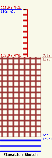
| Elevation Info |
Site Elevation: 182.9 meters (600 ft) |
| Height of Structure: 110 meters (361 feet) |
| Overall Height Above Ground: 110 meters (361 feet) |
| Overall Height Above Mean Sea Level: 292.9 meters (961 feet) |
| Owner Info | Anne's Entertainment Vision, Inc.
1220 Bypass 72
Greenwood, SC 29649
(864) 229-7984
wcrs@wcrs1450am.net |
| Contact Info | Putbrese Hunsaker & Trent, P.C.
200 South Church Street
Woodstock, VA 22664
John Trent
(540) 459-7646
fccman3@shentel.net |
