|
|
Antenna Structure Registration 1201235 |
 |
Registration Info | Registration Number: 1201235 |
| File Number: A1236610 |
| FAA Study: 2020-ASO-10834-OE |
| FAA Issue Date: 05/29/2020 |
| Status: Constructed |
| Date Constructed: 10/08/2020 |
| NEPA: N |
Structure Info
| Structure Type: LTOWER |
| Structure Coordinates: 37-37-19.9 N 82-18-58.1 W (NAD 83) |
| Structure Coordinates: 37-37-19.5 N 82-18-58.6 W (Converted to NAD 27) |
| Structure Address: 1.9 Km North Northeast Of Canada (pike County) Ky |
| Structure City: Canada, KY |
| Structure County: Pike County |
| Painting & Lighting Info |
FAA Circular #: 70/7460-1L |
FAA Chapters: 4, 6, 12 |
Remarks: PRIOR STUDY 2019-ASO-696-OE |
| Elevation Info |
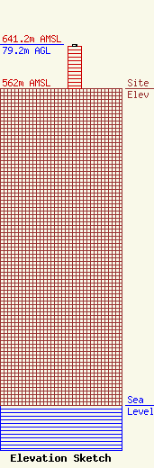
Site Elevation: 562 meters (1844 ft) |
| Height of Structure: 76.2 meters (250 feet) |
| Overall Height Above Ground: 79.2 meters (260 feet) |
| Overall Height Above Mean Sea Level: 641.2 meters (2104 feet) |
| Owner Info | East Kentucky Network, LLC d/b/a Appalachian Wireless
101 Technology Trail
Ivel, KY 41642
(606) 477-2355
compliance@ekn.com |
| Contact Info | East Kentucky Network, LLC d/b/a Appalachian Wireless
101 Technology Trail
Ivel, KY 41642
Cindy McCarty
(606) 477-2355
compliance@ekn.com |
