|
|
Antenna Structure Registration 1201359 |
 |
Registration Info | Registration Number: 1201359 |
| File Number: A0211927 |
| FAA Study: 84-ASO-2941-OE |
| FAA Issue Date: 01/01/1984 |
| Status: Constructed |
| Date Constructed: 10/31/1984 |
| FAA EMI: N |
| NEPA: N |
Structure Info
| Structure Type: TOWER |
| Structure Coordinates: 36-51-38.1 N 87-28-36.0 W (NAD 83) |
| Structure Coordinates: 36-51-37.9 N 87-28-36.0 W (Converted to NAD 27) |
| Structure Address: 301 Mclean Ave |
| Structure City: Hopkinsville, KY |
| Structure County: Christian County |
| Painting & Lighting Info |
FCC Paragraph(s): 1, 2 |
Remarks: RED LIGHTS/PAINT |
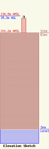
| Elevation Info |
Site Elevation: 201.2 meters (660 ft) |
| Height of Structure: 30.5 meters (100 feet) |
| Overall Height Above Ground: 35.3 meters (116 feet) |
| Overall Height Above Mean Sea Level: 236.5 meters (776 feet) |
| Owner Info | HOPKINSVILLE WATER ENVIRONMENT AUTHORITY
401 E. Ninth Street
628
Hopkinsville, KY 42241
(270) 887-4240
lhale@hwea-ky.com |
| Info |
