|
|
Antenna Structure Registration 1201577 |
 |
Registration Info | Registration Number: 1201577 |
| File Number: A1122291 |
| FAA Study: 99-ASO-4500-OE |
| FAA Issue Date: 09/03/1999 |
| Status: Constructed |
| Date Constructed: 08/27/1999 |
| FAA EMI: N |
| NEPA: N |
Structure Info
| Structure Type: TOWER |
| Structure Coordinates: 34-49-38.3 N 82-17-38.3 W (NAD 83) |
| Structure Coordinates: 34-49-37.9 N 82-17-38.9 W (Converted to NAD 27) |
| Structure Address: 0.97 Km South Of I-85; 0.48 Km West Of I-385; 5.7 Km North Of |
| Structure City: Mauldin, SC |
| Structure County: Greenville County |
| Painting & Lighting Info |
FAA Circular #: 70/7460-1J |
FAA Chapters: 4, 8, 13 |
| Elevation Info |
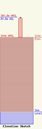
Site Elevation: 300 meters (984 ft) |
| Height of Structure: 76.2 meters (250 feet) |
| Overall Height Above Ground: 80.8 meters (265 feet) |
| Overall Height Above Mean Sea Level: 380.8 meters (1249 feet) |
| Owner Info | Entercom South Carolina, LLC
401 E. City Avenue, Suite 809
Bala Cynwyd, PA 19004
(610) 660-5610
john.kennedy@entercom.com |
| Contact Info | Entercom Communications Corp.
1015 Half Street SE
Washington, DC 20003
Laura Berman
(484) 270-6312
laura.berman@entercom.com |
