|
|
Antenna Structure Registration 1201660 |
 |
Registration Info | Registration Number: 1201660 |
| File Number: A1276493 |
| FAA Study: 99-AEA-1989-OE |
| FAA Issue Date: 08/08/1999 |
| Status: Constructed |
| Date Constructed: 01/15/1950 |
| FAA EMI: N |
| NEPA: N |
Structure Info
|
| Structure Coordinates: 40-57-14.3 N 80-19-2.1 W (NAD 83) |
| Structure Coordinates: 40-57-14.1 N 80-19-02.9 W (Converted to NAD 27) |
| Structure Address: 219 Savannah Gardner Road |
| Structure City: New Castle, PA |
| Structure County: Lawrence County |
| Painting & Lighting Info |
FAA Circular #: 70/7460-1J |
FAA Chapters: 3, 4, 5, 13 |
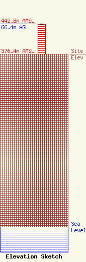
| Elevation Info |
Site Elevation: 376.4 meters (1235 ft) |
| Height of Structure: 65.4 meters (215 feet) |
| Overall Height Above Ground: 66.4 meters (218 feet) |
| Overall Height Above Mean Sea Level: 442.8 meters (1453 feet) |
| Owner Info | Seven Mountains Media Family, LLC
115 West Main Street
Frankfort, KY 40601
(502) 875-1130
towers@7mountainsmedia.com |
| Contact Info | Seven Mountains Media Family, LLC
135 White Bridge Rd
Middletown, NY 10940
Bud Williamson
(914) 213-1710
bud@dre.cc |
