|
|
Antenna Structure Registration 1202745 |
 |
Registration Info | Registration Number: 1202745 |
| File Number: A0154292 |
| FAA Study: 99-ASO-2484-OE |
| FAA Issue Date: 06/29/1999 |
| Status: Granted |
| FAA EMI: N |
| NEPA: N |
Structure Info
| Structure Type: BMAST |
| Structure Coordinates: 38-2-51.2 N 84-30-2.7 W (NAD 83) |
| Structure Coordinates: 38-02-50.9 N 84-30-02.9 W (Converted to NAD 27) |
| Structure Address: 300 West Vine Street |
| Structure City: Lexington, KY |
| Structure County: Fayette County |
| Painting & Lighting Info |
FAA Circular #: 70/7460-1J |
FAA Chapters: 3, 4, 5, 13 |
Remarks: Removed expiration date from determination. Scenario 1./jjs/case#635066 |
Remarks: PRIOR FAA 99-ASO-2282-OE |
| Elevation Info |
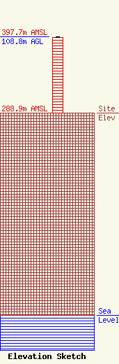
Site Elevation: 288.9 meters (948 ft) |
| Height of Structure: 107.3 meters (352 feet) |
| Overall Height Above Ground: 108.8 meters (357 feet) |
| Overall Height Above Mean Sea Level: 397.7 meters (1305 feet) |
| Owner Info | CUMULUS BROADCAST
300 WEST VINE STREET
1559
LEXINGTON, KY 40592
(859) 253-5900
tom.devine@cumulusb.com |
