|
|
Antenna Structure Registration 1202972 |
 |
Registration Info | Registration Number: 1202972 |
| File Number: A0095684 |
| FAA Study: 90-ASW-1019-OE |
| FAA Issue Date: 09/13/1990 |
| Status: Granted |
| NEPA: N |
Structure Info
| Structure Type: TOWER |
| Structure Coordinates: 34-45-58.3 N 92-17-38.5 W (NAD 83) |
| Structure Coordinates: 34-45-58.0 N 92-17-38.0 W (Converted to NAD 27) |
| Structure Address: 2700 River Road |
| Structure City: North Little Rock, AR |
| Structure County: Pulaski County |
| Painting & Lighting Info |
FAA Circular #: 70/7460-1G |
FAA Chapters: 3, 4, 5, 9 |
| Elevation Info |
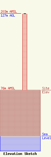
Site Elevation: 76 meters (249 ft) |
| Height of Structure: 126 meters (413 feet) |
| Overall Height Above Ground: 127 meters (417 feet) |
| Overall Height Above Mean Sea Level: 203 meters (666 feet) |
| Owner Info | Joshua Ministries and Comm. Development Corp.
1800 MAPLE ST
2160
North Little Rock, AR 72115
(501) 791-1000
|
| Info |
