|
|
Antenna Structure Registration 1203259 |
 |
Registration Info | Registration Number: 1203259 |
| File Number: A0729701 |
| FAA Study: 79-ASO-1163-OE |
| FAA Issue Date: 07/31/1979 |
| Status: Constructed |
| Date Constructed: 01/01/1980 |
| FAA EMI: N |
| NEPA: N |
Structure Info
| Structure Type: TOWER |
| Structure Coordinates: 35-51-52.6 N 75-38-59.6 W (NAD 83) |
| Structure Coordinates: 35-51-52.0 N 75-39-01.0 W (Converted to NAD 27) |
| Structure Address: 2.4 Kilometers North Of Wanchese |
| Structure City: Wanchese, NC |
| Structure County: Dare County |
| Painting & Lighting Info |
FAA Circular #: 70/7460-1F |
FAA Chapters: 3, 4, 5, 9 |
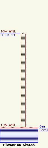
| Elevation Info |
Site Elevation: 1.2 meters (4 ft) |
| Height of Structure: 97.9 meters (321 feet) |
| Overall Height Above Ground: 98.8 meters (324 feet) |
| Overall Height Above Mean Sea Level: 100 meters (328 feet) |
| Owner Info | East Carolina Radio, Inc.
1418
Nags Head, NC 27959
(252) 441-1024
rloesch@ecri.net |
| Contact Info | Graham Brock, Inc.
24466
St. Simons Island, GA 31522-7466
Marilyn Matheny
(912) 638-8028
marilyn@grahambrock.com |
