|
|
Antenna Structure Registration 1203358 |
 |
Registration Info | Registration Number: 1203358 |
| File Number: A1289244 |
| FAA Study: 73-SO-2339-OE |
| FAA Issue Date: 01/31/1974 |
| Status: Dismantled |
| Date Constructed: 01/27/2000 |
| FAA EMI: N |
| NEPA: N |
Structure Info
|
| Structure Coordinates: 33-42-21.0 N 78-53-22.0 W (NAD 83) |
| Structure Coordinates: 33-42-20.4 N 78-53-22.9 W (Converted to NAD 27) |
| Structure Address: 130 Ocala Street |
| Structure City: Myrtle Beach, SC |
| Structure County: Horry County |
| Painting & Lighting Info |
FCC Paragraph(s): 1, 3, 12, 21 |
Remarks: 3 TOWER ARRAY. TOWER(S) 166' AGL HAS NO OM&L REQUIREMENT. 306' AGL TOWER(S) HAS OM&L REQUIREMENT OF RED LIGHTS/PAINT. |
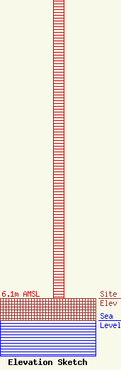
| Elevation Info |
Site Elevation: 6.1 meters (20 ft) |
| Height of Structure: 92.4 meters (303 feet) |
| Overall Height Above Ground: 93.3 meters (306 feet) |
| Overall Height Above Mean Sea Level: 99.4 meters (326 feet) |
| Owner Info | Global Tower, LLC. through American Towers, LLC
10 Presidential Way
Woburn, MA 01801
(678) 564-3236
faa-fcc@americantower.com |
| Contact Info | American Towers, LLC.
10 Presidential Way
Woburn, MA 01801
(678) 564-3236
faa-fcc@americantower.com |
