|
|
Antenna Structure Registration 1204237 |
 |
Registration Info | Registration Number: 1204237 |
| File Number: A0214414 |
| FAA Study: 99-ASW-2466-OE |
| FAA Issue Date: 09/03/1999 |
| Status: Granted |
| FAA EMI: N |
| NEPA: N |
Structure Info
| Structure Type: TOWER |
| Structure Coordinates: 32-34-39.4 N 96-56-21.0 W (NAD 83) |
| Structure Coordinates: 32-34-38.9 N 96-56-20.0 W (Converted to NAD 27) |
| Structure Address: .2 Miles East Of Clark Road & .4 Miles South Of Beltline Road |
| Structure City: Cedar Hill, TX |
| Structure County: Dallas County |
| Painting & Lighting Info |
FCC Paragraph(s): 1, 3, 6, 15, 21 |
Remarks: OM&L CONTINUE PAINT/RED LIGHTS. PRIO FAA 81-ASW-2339-OE |
| Elevation Info |
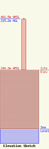
Site Elevation: 246.3 meters (808 ft) |
| Height of Structure: 213.4 meters (700 feet) |
| Overall Height Above Ground: 215.2 meters (706 feet) |
| Overall Height Above Mean Sea Level: 461.5 meters (1514 feet) |
| Owner Info | CLARK PARKERVILLE LP
3728
CEDAR HILL, TX 75106
(972) 293-1374
|
| Info |
