|
|
Antenna Structure Registration 1204967 |
 |
Registration Info | Registration Number: 1204967 |
| File Number: A0152465 |
| FAA Study: 99-ANM-0174-OE |
| Status: Constructed |
| Date Constructed: 11/01/2000 |
| FAA EMI: N |
| NEPA: N |
Structure Info
| Structure Type: TOWER |
| Structure Coordinates: 42-43-48.3 N 114-25-8.1 W (NAD 83) |
| Structure Coordinates: 42-43-48.6 N 114-25-05.0 W (Converted to NAD 27) |
| Structure Address: Flat Top Butte, 5.12 Miles East |
| Structure City: Jerome, ID |
| Structure County: Jerome County |
| Painting & Lighting Info |
FAA Chapters: NONE |
| Elevation Info |
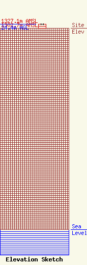
Site Elevation: 1302.7 meters (4274 ft) |
| Height of Structure: 24.4 meters (80 feet) |
| Overall Height Above Ground: 24.4 meters (80 feet) |
| Overall Height Above Mean Sea Level: 1327.1 meters (4354 feet) |
| Owner Info | FISHER BROADCASTING,INC. *
140 N. 16 th STREET
BOISE, ID 83702
(208) 472-2222
LSMITH@2ONLINE.COM |
