|
|
Antenna Structure Registration 1205236 |
 |
Registration Info | Registration Number: 1205236 |
| File Number: A0147714 |
| FAA Study: 94-ANM-0022-OE |
| FAA Issue Date: 01/07/1994 |
| Status: Constructed |
| Date Constructed: 10/01/1995 |
| FAA EMI: N |
| NEPA: N |
Structure Info
| Structure Type: TOWER |
| Structure Coordinates: 37-3-48.9 N 113-34-22.8 W (NAD 83) |
| Structure Coordinates: 37-03-49.0 N 113-34-20.0 W (Converted to NAD 27) |
| Structure Address: Webb Hill |
| Structure City: Saint George, UT |
| Structure County: Washington County |
| Painting & Lighting Info |
FAA Chapters: NONE |
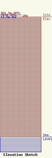
| Elevation Info |
Site Elevation: 947 meters (3107 ft) |
| Height of Structure: 13 meters (43 feet) |
| Overall Height Above Ground: 14.9 meters (49 feet) |
| Overall Height Above Mean Sea Level: 961.9 meters (3156 feet) |
| Owner Info | New Era TacTec
645 North 800 West
cedar City, UT 84720
(435) 586-1189
|
| Contact Info | CARA Enterprises
(175)03
Salt Lake City, UT 84117-8063
Doug Thompson
(801) 278-9728
cdfarm@inquo.net |
