|
|
Antenna Structure Registration 1206018 |
 |
Registration Info | Registration Number: 1206018 |
| File Number: A1308377 |
| FAA Study: 2024-ASO-25252-OE |
| FAA Issue Date: 01/29/2025 |
| Status: Constructed |
| Date Constructed: 10/15/2001 |
| NEPA: N |
Structure Info
| Structure Type: GTOWER |
| Structure Coordinates: 26-41-28.2 N 80-47-17.2 W (NAD 83) |
| Structure Coordinates: 26-41-27.0 N 80-47-18.0 W (Converted to NAD 27) |
| Structure Address: .5 Mile South Of Us 27 And 1mile East Of Lake Harbor |
| Structure City: Lake Harbor, FL |
| Structure County: Palm Beach County |
| Painting & Lighting Info |
FAA Circular #: 70/7460-1J |
FAA Chapters: 3, 4, 5, 13 |
Remarks: OM&L to remain the same as prior study = PAINT/RED LIGHTS |
Remarks: PRIOR STUDY 1999-ASO-2316-OE |
Remarks: OM&L to remain the same as prior study = PAINT/RED LIGHTS |
Remarks: PRIOR STUDY 1999-ASO-2316-OE |
| Elevation Info |
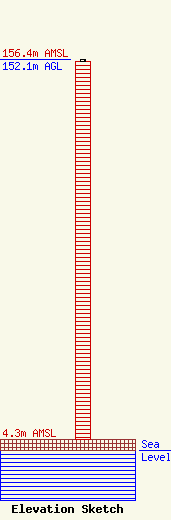
Site Elevation: 4.3 meters (14 ft) |
| Height of Structure: 151.2 meters (496 feet) |
| Overall Height Above Ground: 152.1 meters (499 feet) |
| Overall Height Above Mean Sea Level: 156.4 meters (513 feet) |
| Owner Info | RADIO FIESTA, INC.
530 EAST ALVERDEZ AVE
CLEWISTON, FL 33440
(561) 625-5900
jim@gladesmedia.com |
| Contact Info | RADIOTVLAW ASSOCIATES, LLC
4101 ALBEMARLE ST NW #324
WASHINGTON, DC 20016
ANTHONY LEPORE
(202) 681-2201
anthony@radiotvlaw.net |
