|
|
Antenna Structure Registration 1206058 |
 |
Registration Info | Registration Number: 1206058 |
| File Number: A0860623 |
| FAA Study: 86-ANM-0030-OE |
| FAA Issue Date: 05/15/1986 |
| Status: Dismantled |
| Date Constructed: 05/15/1986 |
| FAA EMI: N |
| NEPA: N |
Structure Info
| Structure Type: TOWER |
| Structure Coordinates: 42-43-47.7 N 114-25-9.1 W (NAD 83) |
| Structure Coordinates: 42-43-48.0 N 114-25-06.0 W (Converted to NAD 27) |
| Structure Address: 8200 Feet East Of Jerome County Airport |
| Structure City: Jerome, ID |
| Structure County: Jerome County |
| Painting & Lighting Info |
FCC Paragraph(s): 1, 3, 11, 21 |
Remarks: RED LIGHTS/PAINT |
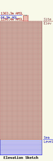
| Elevation Info |
Site Elevation: 1298.4 meters (4260 ft) |
| Height of Structure: 62.8 meters (206 feet) |
| Overall Height Above Ground: 64.9 meters (213 feet) |
| Overall Height Above Mean Sea Level: 1363.3 meters (4473 feet) |
| Owner Info | King Broadcasting Company
5407 Fairview Avenue
Boise, ID 83706
(208) 375-7277
|
| Contact Info | Wiley Rein & Fielding LLP
1776 K Street, N.W.
Washington, DC 20006
John Burgett
(509) 448-2000
|
