|
|
Antenna Structure Registration 1207793 |
 |
Registration Info | Registration Number: 1207793 |
| File Number: A0727846 |
| FAA Study: 2011-ASW-2455-OE |
| FAA Issue Date: 05/10/2011 |
| Status: Constructed |
| Date Constructed: 11/14/1999 |
| FAA EMI: N |
| NEPA: N |
Structure Info
| Structure Type: BANT |
| Structure Coordinates: 29-57-1.2 N 90-4-16.3 W (NAD 83) |
| Structure Coordinates: 29-57-00.5 N 90-04-16.0 W (Converted to NAD 27) |
| Structure Address: 701 Poydras St (one Shell Square Bldg) |
| Structure City: New Orleans, LA |
| Structure County: Orleans Parish |
| Painting & Lighting Info |
FAA Circular #: 70/7460-1K |
FAA Chapters: 4, 5, 12 |
Remarks: PRIOR STUDY 1999-ASW-4147-OE |
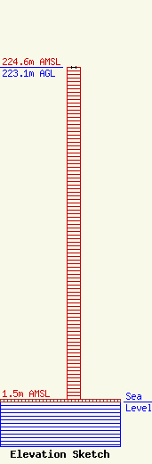
| Elevation Info |
Site Elevation: 1.5 meters (5 ft) |
| Height of Structure: 223.1 meters (732 feet) |
| Overall Height Above Ground: 223.1 meters (732 feet) |
| Overall Height Above Mean Sea Level: 224.6 meters (737 feet) |
| Owner Info | Metropolitan Life Insurance Company
5420 LBJ Freeway, Suite 1310
Dallas, TX 75240
(972) 404-4350
|
| Contact Info | Spectrum Site Management Corporation
510 Bering Dr, Suite 500
Houston, TX 77057
Marvin Goodman
(713) 570-3005
spectrum@crowncastle.com |
