|
|
Antenna Structure Registration 1208419 |
 |
Registration Info | Registration Number: 1208419 |
| File Number: A0109561 |
| FAA Study: 74-SO-2544-OE |
| FAA Issue Date: 12/26/1974 |
| Status: Constructed |
| Date Constructed: 10/18/1976 |
| NEPA: N |
Structure Info
| Structure Type: TOWER |
| Structure Coordinates: 33-27-52.4 N 89-44-11.2 W (NAD 83) |
| Structure Coordinates: 33-27-52.0 N 89-44-10.9 W (Converted to NAD 27) |
| Structure Address: Hiway 515 1.2 Miles South Of Downtown |
| Structure City: Winona, MS |
| Structure County: Montgomery County |
| Painting & Lighting Info |
FAA Circular #: |
FCC Paragraph(s): 1, 2 |
Remarks: RED LIGHTS/PAINT |
| Elevation Info |
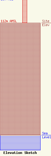
Site Elevation: 112 meters (367 ft) |
| Height of Structure: 26 meters (85 feet) |
| Overall Height Above Ground: 26 meters (85 feet) |
| Overall Height Above Mean Sea Level: 138 meters (453 feet) |
| Owner Info | Southern Electronics, Inc.
746
Winona, MS 38967
(662) 283-1570
hawg951@network-one.com |
