|
|
Antenna Structure Registration 1208973 |
 |
Registration Info | Registration Number: 1208973 |
| File Number: A1342092 |
| FAA Study: 00-ASO-0007-OE |
| FAA Issue Date: 01/24/2000 |
| Status: Constructed |
| Date Constructed: 02/20/2001 |
| NEPA: N |
Structure Info
| Structure Type: TOWER |
| Structure Coordinates: 34-13-51.7 N 77-54-10.9 W (NAD 83) |
| Structure Coordinates: 34-13-51.1 N 77-54-11.9 W (Converted to NAD 27) |
| Structure Address: 3233 Burnt Mill Road |
| Structure City: Wilmington, NC |
| Structure County: New Hanover County |
| Painting & Lighting Info |
FAA Circular #: |
FAA Chapters: NONE |
Remarks: Removed expiration date from determination. Scenario 1./jjs/case#635066 |
| Elevation Info |
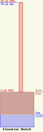
Site Elevation: 8.8 meters (29 ft) |
| Height of Structure: 35.3 meters (116 feet) |
| Overall Height Above Ground: 35.3 meters (116 feet) |
| Overall Height Above Mean Sea Level: 44.1 meters (145 feet) |
| Owner Info | VB Nimbus, LLC
22 W Atlantic Avenue
Delray Beach, FL 33444
(561) 406-4015
fcc-faa@verticalbridge.com |
| Contact Info | VB Nimbus, LLC
22 W Atlantic Avenue
Delray Beach, FL 33444
Richard Hickey
(561) 406-4015
fcc-faa@verticalbridge.com |
