|
|
Antenna Structure Registration 1209110 |
 |
Registration Info | Registration Number: 1209110 |
| File Number: A1342093 |
| FAA Study: 99-ASW-2950-OE |
| FAA Issue Date: 01/03/2000 |
| Status: Constructed |
| Date Constructed: 03/09/2001 |
| FAA EMI: N |
| NEPA: N |
Structure Info
| Structure Type: TOWER |
| Structure Coordinates: 32-46-44.4 N 96-55-23.0 W (NAD 83) |
| Structure Coordinates: 32-46-43.9 N 96-55-22.0 W (Converted to NAD 27) |
| Structure Address: N Side Of Singleton Rd., .2 Mi W Of Intersection Winnequah |
| Structure City: Dallas, TX |
| Structure County: Dallas County |
| Painting & Lighting Info |
FAA Circular #: 70/7460-1J |
FAA Chapters: 4, 8, 13 |
Remarks: Removed expiration date from determination. Scenario 1./jjs/case#635066 |
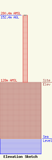
| Elevation Info |
Site Elevation: 128 meters (420 ft) |
| Height of Structure: 152.4 meters (500 feet) |
| Overall Height Above Ground: 152.4 meters (500 feet) |
| Overall Height Above Mean Sea Level: 280.4 meters (920 feet) |
| Owner Info | VB Nimbus, LLC
22 W Atlantic Avenue
Delray Beach, FL 33444
(561) 406-4015
fcc-faa@verticalbridge.com |
| Contact Info | VB Nimbus, LLC
22 W Atlantic Avenue
Delray Beach, FL 33444
Richard Hickey
(561) 406-4015
fcc-faa@verticalbridge.com |
