|
|
Antenna Structure Registration 1209444 |
 |
Registration Info | Registration Number: 1209444 |
| File Number: A0184679 |
| FAA Study: 99-AWP-2397-OE |
| FAA Issue Date: 01/26/2000 |
| Status: Constructed |
| Date Constructed: 06/01/2000 |
| FAA EMI: N |
| NEPA: N |
Structure Info
| Structure Type: POLE |
| Structure Coordinates: 19-42-55.0 N 155-5-5.0 W (NAD 83) |
| Structure Coordinates: 19-43-05.9 N 155-05-15.0 W (Converted to NAD 27) |
| Structure Address: 920 Ululani St. |
| Structure City: Hilo, HI |
| Structure County: Hawaii County |
| Painting & Lighting Info |
FAA Chapters: NONE |
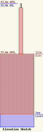
| Elevation Info |
Site Elevation: 23.8 meters (78 ft) |
| Height of Structure: 18.2 meters (60 feet) |
| Overall Height Above Ground: 19.8 meters (65 feet) |
| Overall Height Above Mean Sea Level: 43.6 meters (143 feet) |
| Owner Info | Hawaii County Civil Defense Agency, County of Hawaii
34-A Rainbow Drive
Hilo, HI 96720
(808) 935-0031
|
| Contact Info | Hawaii County Civil Defense Agency
920 Ululani St.
Hilo, HI 96720
Harry Kim
(808) 935-0031
|
