|
|
Antenna Structure Registration 1210098 |
 |
Registration Info | Registration Number: 1210098 |
| File Number: A1262381 |
| FAA Study: 97-ASO-0666-OE |
| FAA Issue Date: 06/20/1997 |
| Status: Constructed |
| Date Constructed: 03/15/1999 |
| FAA EMI: N |
| NEPA: N |
Structure Info
| Structure Type: TOWER |
| Structure Coordinates: 36-8-19.1 N 88-15-52.0 W (NAD 83) |
| Structure Coordinates: 36-08-18.9 N 88-15-51.8 W (Converted to NAD 27) |
| Structure Address: 28433 Vale Rd |
| Structure City: Ephesus, TN |
| Structure County: Carroll County |
| Painting & Lighting Info |
FAA Circular #: 70/7460-1J |
FAA Chapters: 3, 4, 5, 13 |
Remarks: STRUCTURE REACHED GREATEST HEIGHT 2/7/99 |
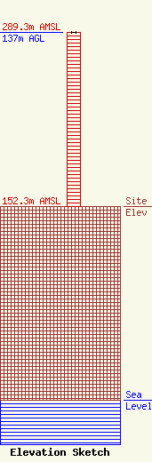
| Elevation Info |
Site Elevation: 152.3 meters (500 ft) |
| Height of Structure: 137 meters (449 feet) |
| Overall Height Above Ground: 137 meters (449 feet) |
| Overall Height Above Mean Sea Level: 289.3 meters (949 feet) |
| Owner Info | Forever Communications, Inc.
351 Pascoe Blvd
Bowling Green, KY 42104
(270) 843-3333
chris@forevercom.com |
| Contact Info | Forever Communications, Inc.
351 Pascoe Blvd
Bowling Green, KY 42104
Christine Hillard
(270) 843-3333
chris@forevercom.com |
