|
|
Antenna Structure Registration 1210491 |
 |
Registration Info | Registration Number: 1210491 |
| File Number: A1297454 |
| FAA Study: 99-ASO-3803-OE |
| FAA Issue Date: 09/23/1999 |
| Status: Constructed |
| Date Constructed: 08/02/1999 |
| FAA EMI: Y |
| NEPA: N |
Structure Info
|
| Structure Coordinates: 32-12-49.9 N 90-22-56.5 W (NAD 83) |
| Structure Coordinates: 32-12-49.4 N 90-22-56.2 W (Converted to NAD 27) |
| Structure Address: 6.4 Kilometers Southeast Of Raymond |
| Structure City: Raymond, MS |
| Structure County: Hinds County |
| Painting & Lighting Info |
FAA Circular #: 70/7460-1J |
FAA Chapters: 3, 4, 5, 13 |
Remarks: PRIOR FAA 98-ASO-1338-OE |
| Elevation Info |
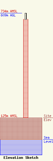
Site Elevation: 125 meters (410 ft) |
| Height of Structure: 573 meters (1880 feet) |
| Overall Height Above Ground: 609 meters (1998 feet) |
| Overall Height Above Mean Sea Level: 734 meters (2408 feet) |
| Owner Info | Gray Local Media, Inc.
4370 Peachtree Road, NE
Atlanta, GA 30319
(404) 266-8333
legalnotices@graymedia.com |
| Contact Info | Gray Local Media, Inc.
4370 Peachtree Road NE
Atlanta, GA 30319
Engineering Department
(404) 266-8333
legalnotices@graymedia.com |
