|
|
Antenna Structure Registration 1211125 |
 |
Registration Info | Registration Number: 1211125 |
| File Number: A0119510 |
| FAA Study: 99-AGL-6417-OE |
| FAA Issue Date: 01/09/2000 |
| Status: Granted |
| NEPA: N |
Structure Info
| Structure Type: TOWER |
| Structure Coordinates: 46-47-30.2 N 92-7-8.5 W (NAD 83) |
| Structure Coordinates: 46-47-30.4 N 92-07-07.8 W (Converted to NAD 27) |
| Structure Address: 200 Feet Ne Of Intersection Of 5th Avenue West And 14th Street West |
| Structure City: Duluth, MN |
| Structure County: St. Louis County |
| Painting & Lighting Info |
FAA Circular #: 70/7460-1J |
FAA Chapters: 3, 4, 5, 13 |
Remarks: PRIOR FAA 98-AGL-4952-OE |
| Elevation Info |
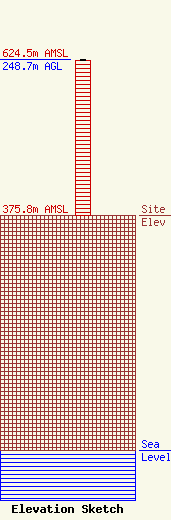
Site Elevation: 375.8 meters (1233 ft) |
| Height of Structure: 247.8 meters (813 feet) |
| Overall Height Above Ground: 248.7 meters (816 feet) |
| Overall Height Above Mean Sea Level: 624.5 meters (2049 feet) |
| Owner Info | Northland Broadcasting, LLC c/o Brill Media Company
3353
Evansville, IN 47732
(812) 423-6200
|
| Contact Info | Graham Brock, Inc.
10 Sylvan Drive, Suite 26
24466
St. Simons Island, GA 31522
Marilyn Matheny
(912) 638-8028
marilyn@grahambrock.com |
