|
|
Antenna Structure Registration 1211446 |
 |
Registration Info | Registration Number: 1211446 |
| File Number: A1064519 |
| FAA Study: 00-AGL-0593-OE |
| Status: Constructed |
| Date Constructed: 07/08/2001 |
| FAA EMI: N |
| NEPA: N |
Structure Info
| Structure Type: TOWER |
| Structure Coordinates: 40-34-30.1 N 88-50-15.3 W (NAD 83) |
| Structure Coordinates: 40-34-30.0 N 88-50-15.0 W (Converted to NAD 27) |
| Structure Address: 8.7 Km, 211.58 Degrees True From Lexington, Il |
| Structure City: Lexington, IL |
| Structure County: McLean County |
| Painting & Lighting Info |
FAA Circular #: 70/7460-1K |
FAA Chapters: 3, 4, 5, 8 |
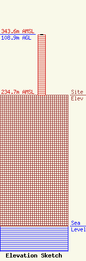
| Elevation Info |
Site Elevation: 234.7 meters (770 ft) |
| Height of Structure: 107.9 meters (354 feet) |
| Overall Height Above Ground: 108.9 meters (357 feet) |
| Overall Height Above Mean Sea Level: 343.6 meters (1127 feet) |
| Owner Info | Pilot Media, LLC
108 Boeykens Pl
Normal, IL 61761
(309) 242-4244
jon@gpmbloomington.com |
| Contact Info | Pilot Media, LLC
108 Boeykens Pl
Normal, IL 61761
Jon Hall
(309) 242-4244
jon@gpmbloomington.com |
