|
|
Antenna Structure Registration 1211744 |
 |
Registration Info | Registration Number: 1211744 |
| File Number: A1224156 |
| FAA Study: 2021-ACE-10068-OE |
| FAA Issue Date: 10/03/2022 |
| Status: Constructed |
| Date Constructed: 09/15/2003 |
| NEPA: N |
Structure Info
| Structure Type: GTOWER |
| Structure Coordinates: 39-5-25.8 N 94-28-19.2 W (NAD 83) |
| Structure Coordinates: 39-05-25.8 N 94-28-18.4 W (Converted to NAD 27) |
| Structure Address: 1603 South Menown Ave. (35238 / Independence Broadcast Mo) |
| Structure City: Independance, MO |
| Structure County: Jackson County |
| Painting & Lighting Info |
FAA Circular #: 70/7460-1J |
FAA Chapters: 4, 9, 13 |
Remarks: OM&L to remain the same as prior study = A HIGH-DUAL SYSTEM |
Remarks: PRIOR STUDY 1999-ACE-1194-OE |
Remarks: OM&L to remain the same as prior study = A HIGH-DUAL SYSTEM |
Remarks: PRIOR STUDY 1999-ACE-1194-OE |
| Elevation Info |
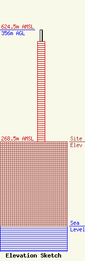
Site Elevation: 268.5 meters (881 ft) |
| Height of Structure: 320.3 meters (1051 feet) |
| Overall Height Above Ground: 356 meters (1168 feet) |
| Overall Height Above Mean Sea Level: 624.5 meters (2049 feet) |
| Owner Info | American Towers, LLC
10 Presidential Way
Woburn, MA 01801
(781) 926-4500
faa-fcc@americantower.com |
| Contact Info | American Towers, LLC
10 Presidential Way
Woburn, MA 01801
(781) 926-4500
faa-fcc@americantower.com |
