|
|
Antenna Structure Registration 1212674 |
 |
Registration Info | Registration Number: 1212674 |
| File Number: A1090561 |
| FAA Study: 2011-ASW-1166-OE |
| FAA Issue Date: 02/28/2011 |
| Status: Constructed |
| Date Constructed: 04/30/2001 |
| FAA EMI: N |
| NEPA: N |
Structure Info
|
| Structure Coordinates: 29-59-38.3 N 95-14-58.7 W (NAD 83) |
| Structure Coordinates: 29-59-37.5 N 95-14-57.9 W (Converted to NAD 27) |
| Structure Address: 327 Wilson Rod |
| Structure City: Humble, TX |
| Structure County: Harris County |
| Painting & Lighting Info |
FAA Chapters: NONE |
Remarks: PRIOR STUDY 2000-ASW-1831-OE |
| Elevation Info |
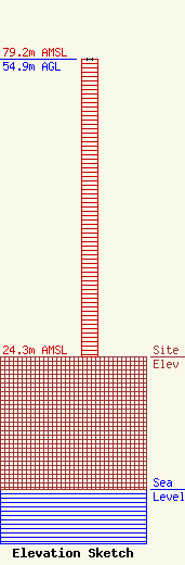
Site Elevation: 24.3 meters (80 ft) |
| Height of Structure: 54.9 meters (180 feet) |
| Overall Height Above Ground: 54.9 meters (180 feet) |
| Overall Height Above Mean Sea Level: 79.2 meters (260 feet) |
| Owner Info | KSBJ Educational Foundation
1722 Treble Drive
Humble, TX 77338
(281) 446-5725
sthompson@ksbj.org |
| Contact Info | KSBJ Educational Foundation
1722 Treble Drive
Humble, TX 77338
Steven Thompson
(281) 446-5725
sthompson@ksbj.org |
