|
|
Antenna Structure Registration 1213618 |
 |
Registration Info | Registration Number: 1213618 |
| File Number: A1106680 |
| FAA Study: 00-ASO-2933-OE |
| FAA Issue Date: 06/05/2000 |
| Status: Constructed |
| Date Constructed: 06/01/2001 |
| FAA EMI: N |
| NEPA: N |
Structure Info
| Structure Type: TOWER |
| Structure Coordinates: 35-12-52.5 N 80-51-19.3 W (NAD 83) |
| Structure Coordinates: 35-12-52.0 N 80-51-20.0 W (Converted to NAD 27) |
| Structure Address: 1520 S. Boulevard |
| Structure City: Charlotte, NC |
| Structure County: Mecklenburg County |
| Painting & Lighting Info |
FAA Chapters: NONE |
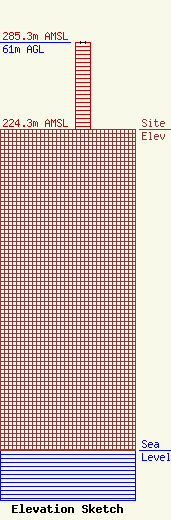
| Elevation Info |
Site Elevation: 224.3 meters (736 ft) |
| Height of Structure: 61 meters (200 feet) |
| Overall Height Above Ground: 61 meters (200 feet) |
| Overall Height Above Mean Sea Level: 285.3 meters (936 feet) |
| Owner Info | Beasley Media Group Licenses, LLC
3033 Riviera Drive, Suite 200
Naples, FL 34103
(239) 263-5000
mike.cooney@bbgi.com |
| Contact Info | Lerman Senter PLLC
2001 L Street, NW
Washington, DC 20036
Sally Buckman
(202) 429-8970
sbuckman@lermansenter.com |
