|
|
Antenna Structure Registration 1214160 |
 |
Registration Info | Registration Number: 1214160 |
| File Number: A1299940 |
| FAA Study: 00-ASO-2415-OE |
| FAA Issue Date: 06/13/2000 |
| Status: Constructed |
| Date Constructed: 07/30/2001 |
| FAA EMI: N |
| NEPA: N |
Structure Info
|
| Structure Coordinates: 36-48-29.2 N 87-38-9.0 W (NAD 83) |
| Structure Coordinates: 36-48-29.0 N 87-38-09.0 W (Converted to NAD 27) |
| Structure Address: 0.3 Km W Of Ky Hwy 117, 1.1 Km N Of Hwy 117/164 Intersection Christian Co., Ky |
| Structure City: Hopkinsville, KY |
| Structure County: Christian County |
| Painting & Lighting Info |
FAA Circular #: 70/7460-1K |
FAA Chapters: 3, 4, 5, 12 |
Remarks: Removed expiration date from determination. Scenario 1./jjs/case#635066 |
Remarks: SUPPLEMENTAL NOTICE STATES STRUCTURE REACHED GREATEST HEIGHT ON 07/30/2001 |
Remarks: Removed expiration date from determination. Scenario 1./jjs/case#635066 |
| Elevation Info |
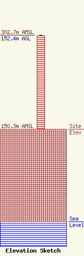
Site Elevation: 150.3 meters (493 ft) |
| Height of Structure: 151.5 meters (497 feet) |
| Overall Height Above Ground: 152.4 meters (500 feet) |
| Overall Height Above Mean Sea Level: 302.7 meters (993 feet) |
| Owner Info | DJE, LLC
19 DJ Everett Drive
1900
CADIZ, KY 42211
(270) 522-3232
bmann@wkdzradio.com |
| Contact Info | RADIOTVLAW ASSOCIATES, LLC
4101 ALBEMARLE ST NW #324
WASHINGTON, DC 20016
ANTHONY LEPORE
(202) 681-2201
anthony@radiotvlaw.net |
