|
|
Antenna Structure Registration 1214911 |
 |
Registration Info | Registration Number: 1214911 |
| File Number: A0916205 |
| FAA Study: 2014-ANM-1235-OE |
| FAA Issue Date: 06/09/2014 |
| Status: Constructed |
| Date Constructed: 07/21/2000 |
| FAA EMI: N |
| NEPA: N |
Structure Info
| Structure Type: GTOWER |
| Structure Coordinates: 45-45-49.3 N 108-27-20.4 W (NAD 83) |
| Structure Coordinates: 45-45-49.5 N 108-27-17.9 W (Converted to NAD 27) |
| Structure Address: Colburn Hill 2.6 Mi Ese |
| Structure City: Billings, MT |
| Structure County: Yellowstone County |
| Painting & Lighting Info |
FAA Circular #: 70/7460-1K |
FAA Chapters: 3, 4, 5, 12 |
Remarks: PRIOR STUDY 2000-ANM-1109-OE |
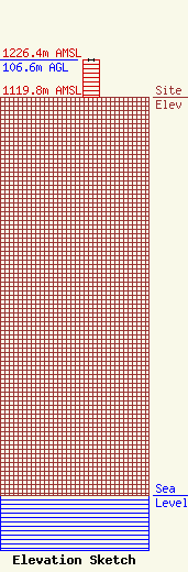
| Elevation Info |
Site Elevation: 1119.8 meters (3674 ft) |
| Height of Structure: 105.2 meters (345 feet) |
| Overall Height Above Ground: 106.6 meters (350 feet) |
| Overall Height Above Mean Sea Level: 1226.4 meters (4024 feet) |
| Owner Info | SBA GC Towers, LLC
8051 Congress Avenue
Boca Raton, FL 33487
(561) 995-7670
ERoach@sbasite.com |
| Contact Info | SBA GC Towers, LLC
8051 Congress Avenue
Boca Raton, FL 33487
(561) 995-7670
ERoach@sbasite.com |
