|
|
Antenna Structure Registration 1215035 |
 |
Registration Info | Registration Number: 1215035 |
| File Number: A1150937 |
| FAA Study: 00-ASO-3221-OE |
| FAA Issue Date: 07/12/2000 |
| Status: Constructed |
| Date Constructed: 01/01/2000 |
| FAA EMI: N |
| NEPA: N |
Structure Info
| Structure Type: TOWER |
| Structure Coordinates: 30-27-47.0 N 84-21-28.0 W (NAD 83) |
| Structure Coordinates: 30-27-46.3 N 84-21-28.3 W (Converted to NAD 27) |
| Structure Address: 3411 W. Tharpe Street |
| Structure City: Tallahassee, FL |
| Structure County: Leon County |
| Painting & Lighting Info |
FAA Chapters: NONE |
Remarks: Removed expiration date from determination. Scenario 1./jjs/case#635066 |
| Elevation Info |
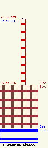
Site Elevation: 30.5 meters (100 ft) |
| Height of Structure: 46.3 meters (152 feet) |
| Overall Height Above Ground: 46.3 meters (152 feet) |
| Overall Height Above Mean Sea Level: 76.8 meters (252 feet) |
| Owner Info | Cumulus Broadcasting, LLC
3280 Peachtree Rd, Suite 2200
Atlanta, GA 30305
(404) 949-0700
towermanagement@cumulus.com |
| Contact Info | Cumulus Broadcasting, LLC
2300 Vartan Way, Suite 130
Harrisburg, PA 17110
David Supplee
(717) 901-0720
dave.supplee@cumulus.com |
