|
|
Antenna Structure Registration 1215589 |
 |
Registration Info | Registration Number: 1215589 |
| File Number: A1194798 |
| FAA Study: 00-ASW-1908-OE |
| FAA Issue Date: 05/23/2000 |
| Status: Constructed |
| Date Constructed: 08/01/1979 |
| FAA EMI: N |
| NEPA: N |
Structure Info
| Structure Type: TOWER |
| Structure Coordinates: 32-16-38.0 N 99-35-52.0 W (NAD 83) |
| Structure Coordinates: 32-16-37.5 N 99-35-50.7 W (Converted to NAD 27) |
| Structure Address: Intersection Of 23 Kmse Abilene, Tx, 0.9 Kmse And Tx 36 And Fm 1178 |
| Structure City: Abilene, TX |
| Structure County: Callahan County |
| Painting & Lighting Info |
FCC Paragraph(s): A1, B, D, H |
Remarks: PRIOR FAA 78-ASW-0744-OE CONTINUE OM&L 24-HR HI-STROBES |
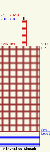
| Elevation Info |
Site Elevation: 673 meters (2208 ft) |
| Height of Structure: 201.2 meters (660 feet) |
| Overall Height Above Ground: 228.3 meters (749 feet) |
| Overall Height Above Mean Sea Level: 901.3 meters (2957 feet) |
| Owner Info | Nexstar Media Inc.
545 E. John Carpenter Freeway
Irving, TX 75062
(972) 373-8800
jasroberts@nexstar.tv |
| Contact Info | Nexstar Media Inc.
545 E. John Carpenter Freeway
Irving, TX 75062
Jason Roberts
(972) 373-8800
jasroberts@nexstar.tv |
