|
|
Antenna Structure Registration 1216338 |
 |
Registration Info | Registration Number: 1216338 |
| File Number: A0654879 |
| FAA Study: 00-ASO-2866-OE |
| FAA Issue Date: 08/29/2000 |
| Status: Constructed |
| Date Constructed: 08/10/2001 |
| FAA EMI: N |
| NEPA: N |
Structure Info
| Structure Type: TOWER |
| Structure Coordinates: 33-55-35.4 N 88-39-46.1 W (NAD 83) |
| Structure Coordinates: 33-55-35.0 N 88-39-45.9 W (Converted to NAD 27) |
| Structure Address: White Rock Rd |
| Structure City: Aberdeen, MS |
| Structure County: Monroe County |
| Painting & Lighting Info |
FAA Circular #: 70/7460-1J |
FAA Chapters: 4, 6, 13 |
Remarks: Removed expiration date from determination. Scenario 1./jjs/case#635066 |
Remarks: PRIOR FAA 00-ASO-0667-OE |
Remarks: Removed expiration date from determination. Scenario 1./jjs/case#635066 |
| Elevation Info |
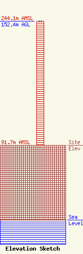
Site Elevation: 91.7 meters (301 ft) |
| Height of Structure: 152.4 meters (500 feet) |
| Overall Height Above Ground: 152.4 meters (500 feet) |
| Overall Height Above Mean Sea Level: 244.1 meters (801 feet) |
| Owner Info | AMERICAN FAMILY ASSOCIATION
P.O. DRAWER 2440
Tupelo, MS 38803
(662) 844-8888
JES@AFA.NET |
| Info |
