|
|
Antenna Structure Registration 1218789 |
 |
Registration Info | Registration Number: 1218789 |
| File Number: A0677171 |
| FAA Study: 2010-AEA-256-OE |
| FAA Issue Date: 01/22/2010 |
| Status: Constructed |
| Date Constructed: 12/31/1996 |
| FAA EMI: N |
| NEPA: N |
Structure Info
| Structure Type: TOWER |
| Structure Coordinates: 40-22-13.2 N 78-58-58.6 W (NAD 83) |
| Structure Coordinates: 40-22-12.9 N 78-58-59.5 W (Converted to NAD 27) |
| Structure Address: Laurel Hill Ridge S. Decker Avenue (pa12102-a) |
| Structure City: Johnstown, PA |
| Structure County: Cambria County |
| Painting & Lighting Info |
FAA Chapters: NONE |
Remarks: PRIOR STUDY 1996-AEA-1637-OE |
| Elevation Info |
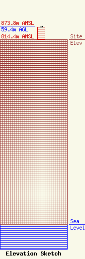
Site Elevation: 814.4 meters (2672 ft) |
| Height of Structure: 54.9 meters (180 feet) |
| Overall Height Above Ground: 59.4 meters (195 feet) |
| Overall Height Above Mean Sea Level: 873.8 meters (2867 feet) |
| Owner Info | SBA Towers II LLC
8051 Congress Avenue
Boca Raton, FL 33487
(561) 995-7670
ERoach@sbasite.com |
| Contact Info | SBA Towers II LLC
8051 Congress Avenue
Boca Raton, FL 33487
Edward Roach
(561) 995-7670
ERoach@sbasite.com |
